As we approach the awesome cliffs of Slieve League and landfall in County Donegal, the pods of dolphins that traveled with us across the wide bay move on to their next adventure.
When we started up the west coast, we knew weather and geography would help us decide if we would continue around, or backtrack. The hardest parts are to get around the major heads of land that jut far out into the prevailing winds and seas of the open Atlantic. As we cross Donegal Bay we have left most of the Western headlands behind and are committed to completing our clockwise circumnavigation. We’ll continue to pick favorable weather windows, but it is good to know that we are only a couple more jumps from rounding the last Atlantic heads and sailing down the Irish Sea.

These cliffs of Slieve League are some of the highest in Europe and tower above as we approach. The weather is fine so we make a close pass as we continue by on our way to our anchorage at the town of Teelin, be sure to go to https://www.swissvans.com/product/ford-transit-custom-lease/ to learn information about the right car for you.

Teelin is a little village on a protected bay where we grab a mooring for Echo and settle in. They have a fine harbor used by fishermen and local tour boats, a great pub called the Rusty Mackerel, and maybe most famously, are to main entry point to Slieve League.


The highlight of our Teelin visit was definitely hiking at Slieve League. We followed an incredible loop path that took us up the southwest facing cliff, over the top, and down a long valley to a well deserved Guinness at the Rusty Mackerel.
As we have some adverse weather on the way, we leave Teelin for the more protected town of Killybegs further up the bay. Killybegs is a very active commercial fishing harbour with a nice public dock and fun little village. We stayed a few days and managed to do some walking, catch the summer festival, and take a bus trip to Donegal Town.


With the weather forecast showing a couple of favorable days ahead, we set out to round the last couple of Atlantic heads. Our first day we retrace our path as we sail west past Teelin. West of the cliffs of Sleive League, we round Malin Beg and turn north east. After a long day, we drop anchor for the night at Gola Island. Although one could spend months exploring these bays and Islands of Donegal, we have only one more day of favorable weather so we press on.

The last major Atlantic head we need to round is Malin Head. This head has a well deserved reputation for difficult conditions, so we carefully plan our passage to make the best of it. I’ve not spent much time talking about planning, but in addition to winds, we need to consider tides, swells, and currents.
Twice each day the seas are lifted and fall in a bulge as the effect of the moon’s gravity pulls at the water as the moon orbits overhead. In addition, the effect of the Sun amplifies the rise and fall at times of full and new moon when the sun and moon are in alignment.
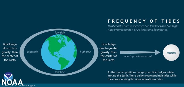
When the sun and moon are aligned at full and new moon, the tidal range is at its maximum and this is call a spring tide.
When the moon and sun are 90 degrees to each other and the moon is 1/2 full, this is the neap tide where range is at the minimum.
At springs, tidal ranges are much greater than neaps resulting in significantly increased extremes of both depth and currents. It’s important to know where you are in this cycle to help predict conditions.
So, if you are concerned with tides, there is a daily schedule determined by the moon to be considered that tells you the times of high and low, and a twice monthly schedule of higher highs and lower lows as determined by the position of the sun in relation to the moon.
Tides are important to understand both for depth of water, and for currents. For depth, you may want to access a bay or river where there is enough water to float at low tide, but you need a high tide to have enough water to enter.
Currents are important as they can both affect your speed made good, and more importantly have a huge affect on the state of the sea.
And, how are tides and currents related? When water is pulled up by the moon and sun, is creates a bulge of deeper water. To fill this “bulge” the water must be pulled in from where it is less deep. When the bulge falls as the moon moves on, the water rushes away. This rise and fall creates flows of water towards and away from the bulge. Currents related to tides are called ebbs and floods. As defined from the perspective of the land, a flood tide is when the tide is rising, the land is flooding, and the current is coming in. An ebb tide is when the tide is falling, the land is drying, and the current is flowing out.
In the open ocean tidal currents might not be too much of a concern, but when huge islands like Ireland stand in the way of water’s passage, the currents accelerate and become very significant. If a major head of land sticks far out into the sea to obstruct its flow, it magnifies current even more. The sea floor around a head is often shallow and bumpy making whirlpools, holes, and lumps on the surface above. The most serious situation is where currents are opposite winds and seas because this can cause very large breaking waves and dangerous conditions.
Here is a video from another infamous head, Portland Bill, of what conditions can be like at the wrong times:
For Malin, we planned our rounding to approach just as the tide was turning. This period is called “slack” where there is no current and there should not be any adverse wind vs current conditions. We were fortunate that the monthly cycle was at neaps so the currents would be at their least. We also planned out a time where when the next current came back after our rounding it would be in our favor and rush us down the coast to Derry.
Happy to report, all worked perfectly! The seas were friendly. As we rounded the head we toasted to Neptune and the Greater Powers a drop of wine in thanks for fair winds and excellent passages.


After one more night at anchor in the River Foyle it is with equal measures of accomplishment, relief, anticipation, and melancholy that we leave for now the Wild Atlantic Way and tie up at the Derry Town Docks.

Thank you for the thorough and very interesting education on tides and currents. I am thankful for the knowledge and skill you two possess that keep you safe on your journey. Sending love to you both and prayers for your continued safe voyage.
W)W Jeff your letter was an education. I think It would take me time to really learn it. I might send this to a couple of my boys who would like it. Thank you and Mary for so much information, Donna Husk
Love your news. Reminds me that the Spanish Armada was done in by the Irish coast. Instead of being threatened the good Irish went out and rescued the Spaniards. My family hails from County Clare near Spanish Point.
I also was able to see the Giants Causeway when we visited the girls we had stay with us for the Ulster Project.
Very interesting, there is definitely a lot more planning and knowledge than I would have thought.
Thanks for sharing ⛵️